
The origins of the name Yucatán are disputed but most scholars believe that the name refers to the Aztec word Yocatlān that means “place of richness. The peninsula played a significant role in the Mayan civilization and the area is filled with sites that attest to its importance throughout the centuries.
Today the Yucatán is becoming a vacation spot for visitors from throughout the world who want a break from the Vegas casino – type of trip. The Yucatán’s historical, cultural and natural sites offer travelers the chance to escape from the pressures of the modern world and experience a simple, restful and interesting get-away.
Some Yucatán sites that are most popular among travelers include:
National Reef Park of Puerto Morelos
The Mesoamerican Barrier Reef runs parallel to the Yucatan Peninsula and is the second-largest coral reef in the world, — only the Great Barrier Reef in Australia is larger. When you go to the National Reef Park of Puerto Morelos you’ll be able to view the reef up close since it’s closer to the shore than in other areas of the Riviera Maya. Today this section of the reef has become a protected area.
You can walk around the shoreline or join a snorkeling tour or a scuba diving trip. These guided tours are organized by dive shops located in the nearby seaside town of Puerto Morelos. All divers and snorkelers must join a guided tour to get to the reef. It’s illegal to swim solo out to the reef from the shore.

Puerto Morelos (Photo: Archive)
Celestun Wildlife Refuge
The Celestun Wildlife Refuge is a biosphere and wildlife refuge and is a center of fascination for tourists and researchers alike. The estuary (ria) is bordered by a mangrove forest. Fishing for shrimp and blue crab larvae is a mainstay of the local economy.
Migratory birds winter in this refuge which is the first stop on two of the four migratory flyways. Visitors can see warblers and sandpipers among the 400 species that have been spotted in this reserve. Some birds live in the refuge throughout the year while others come only in the winter.
The highlight of a visit to the refuge, for many people, is the flamingo sightings. The American Flamingo, which winters in the refuge, is the largest and most brilliantly colored of the six flamingo species that exist in the world.
Tours take visitors to Bird Island (Isla de Pajaros) to see the area where most of the flamingos congregate. There are also cormorants, frigate birds, and great egrets which nest there at different times. From September through April visitors can often see roseate Spoonbills. The tours generally stop at the Ojo de Agua subterranean river freshwater spring where tour members can swim.
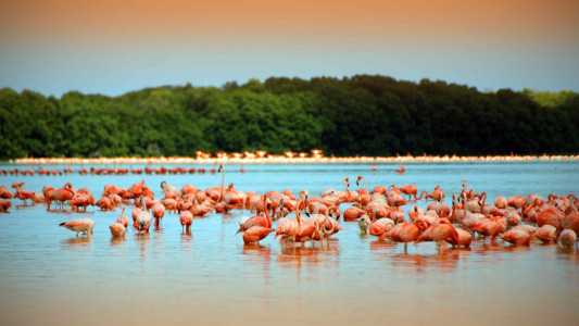
Flamingos at Celestun Lagoon, with the Mangrove in the back (Photo: Google)
El Rey Ruins (Zona Arqueologica El Rey)
El Rey — The King — is one of the most important archaeological zones on the island of Cancun. Early settlement dates back to ancient times. El Rey became an important site in the Late Postclassic (1200 – 1550 AD) era when the town joined with nearby San Miguelito to form a maritime trade and fishing economy.
Today it’s possible to walk among the various structures that are sited along the main road and its two small squares. The site is under continuous archaeological scrutiny with focus on Building Number 2 which contains a pyramidal basement with a temple.
Additional structures have been identified as palaces. Visitors can walk through and see the large galleries and the colonnades which supported the structures’ flat roofs. Archaeologists believe that these structures functioned as administrative buildings where meetings were held that had been arranged between ruling groups.
The area ceased to serve as an economic center when the Spanish conquered the region.
Public transportation is available to the site which is located in the City of Cancun, 10 kilometers south of Cancun’s center.
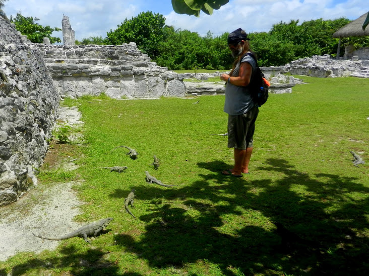
The birds and the iguanas duked it out for the bits of apple at El Rey archaeological site, Cancun (Photo: http://lmaclean.ca/2012/06)
Catedral de San Ildefonso/ Cathedral of Mérida
The Cathedral of San Ildefonso, which became the seat of the bishopric of Yucatán, was built on ancient Mayan ruins in the 16th century.
Pius IV created the diocese of Yucatán in 1561 and St. Ildephonsus of Toledo was named as the patron. Fray Francisco Toral, was consecrated in 1562 and served as the first bishop, and later archbishop, of Yucatán.
Mérida was named the capital of the Yucatán and was established amidst the ruins of the Maya settlement of Ichcansiho. Once Fray Tora arrived, construction of the Cathedral began on the eastern side of the main town square.
Some of the stone from the Maya temple was used in the cathedral’s construction. One of the more unusual features of this cathedral is the system of vaulting that’s used throughout the building.
The massive crucifix behind the altar is Mérida’s most famous religious artifact. It’s called “Cristo de la Unidad” (Christ of Unity). It was meant to be a symbol of reconciliation between the Spaniards and the Mayans. According to legend, the statue was carved from a tree that was hit by lightning and burned throughout the night without charring. A different legend says that the crucifix was the only object to survive the fiery destruction of the church in the town of Ichmul and was then moved to the Mérida cathedral.
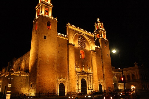
Catedral_de_San_Ildefonso (Photo: Archive)
Kohunlich
Kohunlich is a pre-Columbian Mayan site which is located in Quintana Roo, about 60 kilometers west of Chetumal. The name derives from the words “Cohune Ridge,” referring to the area where the cohune palm plant once grew.
The site dates back to 200 BC, but seems to have seen most of its building activity several hundred years later. Many structures are overgrown by trees and covered with thick vegetation.
Kohunlich remains largely unexcavated. The city was, evidently, an important Mayan center that featured pyramids, citadels, raised platforms, courtyards and plazas. A central drainage system channeled water into cisterns to collect rainwater. The city seems to have been a center for travelers who traveled the trade routes through the southern Yucatan from Rio Bec and Campeche to what is modern Guatamala and Belize.
The most famous site in Kohunlich is the Temple of the Masks. The Temple is one of Kohunlich’s oldest pyramids. The pyramid’s central stairway is flanked by humanized stucco masks. Starting in 700 A.D. the Mayans covered the pyramid with another structure to protect the masks which, even today, are well-preserved. There were originally eight carved masks that flanked the central staircase but, because of looting, only five remain today.

Kohunlich
TYT Newsroom
