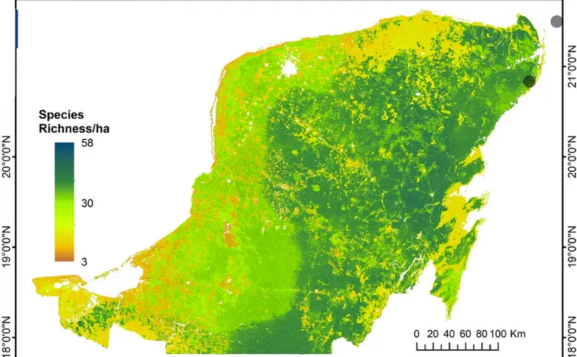
Specialists from the Centro de Investigación Científica de Yucatán (CICY) developed a map of the carbon density and species richness present throughout the Yucatan Peninsula, in order to identify areas suitable for conservation.
After this project by the CICY Resources Unit, it was detected that the areas with the greatest deforestation are those belonging to the Merida metropolitan area, which practically exhibits the lack of biomass and diversity of species in white (alluding to the concrete slab).
It is important to mention that this type of study is carried out in a large part of the national territory.
It is mentioned that there are three main types of forests in the Peninsula: lowland forests, which concentrate from 90 to 150 tons of biomass per hectare; medium sub deciduous forest, which has from 150 to 180 tons of biomass per hectare, and medium sub evergreen forest, which has more than 200 tons per hectare.
TYT Newsroom
more recommended stories
While meeting with governors, Lopez Obrador said that a Global Promigrant plan is urgent
President Andrés Manuel López Obrador insisted,.
Each presidential candidate will receive 661 million pesos
Of the 10.4 billion pesos that.
Medicinal uses of corn in Mexico
Mexican corn is not only a.
African migrants heading to the US obtain low-cost visas in Nicaragua
African migrants and asylum seekers heading.
State police captures the alleged attacker of a woman in the Parque de las Américas
On the night of Tuesday, September.
U.S. and Mexico clash over Genetically Modified Corn
GMO stands for genetically modified organism,.
New charges in Chichén Itzá, even in cleansing Maya rituals
The government of Yucatán announced 16.
Vandals wreck and loot a “Va y ven” vending machine
An automatic vending machine of the.
Parents of the 43 missing students lead a protest in Mexico City
Nine years after the disappearance of.
Mexican Independence Two Centuries Later
Mexican Independence, celebrated proudly every year.
Leave a Comment