

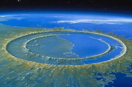
The Chicxulub crater, in the Yucatan Peninsula (Mexico), is more than 180 kilometers in diameter and is the unmistakable sign of the impact caused by a meteorite approximately 65 million years ago. Although some discrepancies remain, several studies indicate that the fall of this asteroid fragment and the subsequent environmental effects were decisive in the extinction of a large part of the dinosaurs and many other groups of animals and plants.
Dozens of studies and graphic simulations have presented over the last few years what the Chicxulub impact could have been like.
Research led by experts from the University of Michigan (UM, in the United States) now presents the most detailed explanation of the extent of this historic event on the coasts and seabed of almost half of the planet, with a graphic simulation of the impact and its effects in the hours and days that followed.
The results of this research have been published in the journal AGU Advances. The University of Michigan, in the results briefing note, states that “the asteroid that struck the Earth 66 million (…) years ago triggered a monstrous tsunami with one-mile (1.6 km) high waves that swept the ocean floor thousands of miles from the impact site in the Yucatan Peninsula”.
“This tsunami was strong enough to disrupt and erode sediments in ocean basins on the other side of the world, leaving a gap in the sedimentary record or a jumble of older sediments,” has explained lead author Molly Range, who conducted the study as part of a graduate thesis. with supervision from U-M oceanographer and study co-author Brian Arbic and U-M paleoceanographer and study co-author Ted Moore .
The review of the geologic record focused on “boundary sections,” marine sediments deposited just before or after the asteroid impact and subsequent mass extinction of the K-Pg, Cretaceous-Tertiary boundary period, the release issued by the University of Michigan said.
Energetic impact.
“The erosion distribution and hiatuses we observed in the Upper Cretaceous marine sediments are consistent with our model results, giving us more confidence in the model predictions,” said Range, who began the project as an undergraduate student in Arbic’s lab in the Department of Environmental and Earth Sciences.
The study authors calculated that the initial energy of the impact tsunami was up to 30,000 times greater than the tsunami energy of the December 2004 Indian Ocean earthquake, which killed more than 230,000 people and is one of the largest tsunamis in modern history.
The team’s simulations show that the impact tsunami radiated mainly eastward and northeastward into the North Atlantic Ocean, and southwestward across the Central American Seaway (which used to separate North and South America) into the South Pacific Ocean.
In the directly affected basins and in some adjacent areas, undercurrent velocities probably exceeded 20 centimeters per second (0.4 mph), a velocity that is strong enough to erode fine-grained sediments on the seafloor.
In the South Atlantic, North Pacific, Indian Ocean and the region that is now the Mediterranean, the seafloor was largely shielded from the strongest tsunami effects, according to the team’s simulation. In those locations, the current modeled velocities were probably below the 20 cm/sec threshold.
For the geologic record review, U-M’s Moore analyzed published records from 165 marine boundary sections and was able to obtain useful information from 120 of them. Most of the sediments came from cores collected during scientific ocean drilling projects.
The North Atlantic and South Pacific had the fewest sites with complete, unbroken K-Pg boundary sediments. In contrast, the greatest number of complete K-Pg boundary sections were found in the South Atlantic, North Pacific, Indian Ocean and Mediterranean.
“We found corroboration in the geologic record of predicted areas of maximum impact in the open ocean,” said Arbic, professor of environmental and earth sciences. He oversaw the project. “The geologic evidence definitely strengthens the paper.”
Of particular importance, according to the authors, are the K-Pg boundary outcrops on the eastern coasts of the northern and southern islands of New Zealand, which are more than 12,000 kilometers (7,500 miles) from the Yucatan impact site.
The heavily disturbed and incomplete New Zealand sediments, called olistostromal deposits, were originally thought to be the result of local tectonic activity. But given the age of the deposits and their location directly in the modeled path of the Chicxulub impact tsunami, the U-M-led research team suspects a different origin.
“We believe these deposits are recording the effects of the impact tsunami, and this is perhaps the strongest confirmation of the global significance of this event,” Range said.
Model comparison
The modeling part of the study used a two-stage strategy. First, a large computer program called hydrocode simulated the chaotic first 10 minutes of the event, which included the impact, crater formation and tsunami initiation. That work was done by co-author Brandon Johnson of Purdue University.
Based on findings from previous studies, the researchers modeled an asteroid that was 14 kilometers (8.7 miles) in diameter and moving at 12 kilometers per second (27,000 mph). It struck a granitic crust covered by thick sediments and shallow ocean waters, opening a crater approximately 100 kilometers wide (62 miles wide) and ejecting dense clouds of soot and dust into the atmosphere.
Two and a half minutes after the asteroid’s impact, a curtain of ejected material pushed a wall of water away from the impact site, briefly forming a 4.5-kilometer-high (2.8-mile-high) wave that subsided as the ejecta fell back down. Earth.
Ten minutes after the projectile hit the Yucatan and 220 kilometers (137 miles) from the point of impact, a 1.5-kilometer-high (0.93-mile-high), ring-shaped, outward-propagating tsunami wave began sweeping the ocean in all directions, according to the UM simulation.
At the 10-minute mark, results from Johnson’s iSALE hydrocode simulations were input into two tsunami propagation models, MOM6 and MOST, to track the giant waves across the ocean. MOM6 has been used to model tsunamis in the deep ocean, and NOAA uses the MOST model operationally for tsunami forecasts at its Tsunami Warning Centers.
TYT Newsroom
