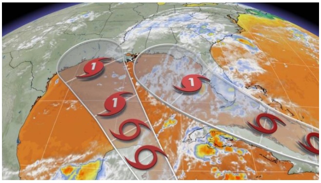
In what has already been an above-average hurricane season, with several named storms being the earliest of their particular letter, forecasters are eyeing what look to be the next entrants into the tropical storm club.
TROPICAL STORM LAURA
In the Atlantic, Tropical Depression 13 has strengthened into Tropical Storm Laura, the 12th earliest named storm on record. Laura is currently 375 kilometres east-southeast of the northern Leeward Islands, according to the National Hurricane Center (NHC).
Laura has maximum sustained winds of around 75 km/h, with its centre located south of the previously estimated position.

“[It is expected to] become a Category 1 hurricane as it tracks into the eastern Gulf of Mexico early next week. However, there are major differences in the intensity forecasts from the models – ranging from a major hurricane to having the storm completely dissipate,” says Weather Network meteorologist Dr. Doug Gillham.
A tropical storm watch is in effect for the southeastern Bahamas, Turks and Caicos Islands, Puerto Rico, Vieques and Culebra, U.S. Virgin Islands, British Virgin Islands, Saba and St. Eustatius, St. Maarten, St. Martin and St. Barthelemy, as well as Antigua, Barbuda, St. Kitts, Nevis, and Anguilla.
TROPICAL DEPRESSION 14
Deeper in the Caribbean, Tropical Depression 14 is expected to strengthen off the Central American coast through Saturday, potentially bringing tropical-storm-force winds and heavy rainfall over portions of the coast of Honduras and the Bay Islands through Friday, according to the NHC.
“Tropical Depression 14 is also expected to become a hurricane early next week as it tracks into the northwestern Gulf of Mexico with landfall along the coast of Louisiana or Texas,” Gillham adds.

However, the timing and strength of the hurricane is somewhat uncertain as it could be influenced by the interaction with what is currently Tropical Storm Laura.
A hurricane watch is in effect for Punta Herrero to Cancun, Mexico.
A tropical storm warning is in effect for Honduras/Nicargua border wastward to Punta Castilla, Honduras, Bay Islands of Honduras, Puerto Cabezas, Nicaragua, northward to the Honduras/Nicaragua border, and from Punta Herrero to Cancun, Mexico.
“On the forecast track, the centre of the system will move near or just offshore the coast of northern Honduras, including the Bay Islands, today and approach the east coast of the Yucatan Peninsula of Mexico on Saturday,” NHC says.
The system is expected to move into the south-central Gulf of Mexico as a tropical storm on Sunday, forecasters with the agency added, in which case it would take the name Marco.
“The system is forecast to be near or at hurricane strength when it reaches the Yucatan Peninsula of Mexico late Saturday. Some weakening is expected as it traverses the Yucatan Peninsula Saturday night. Afterward, restrengthening is forecast on Sunday as it moves offshore and enters the southern Gulf of Mexico,” the NHC says.
Residents in areas of concern are urged to monitor the forecast closely and prepare in advance in case of evacuations.
Depression 14 is expected to produce around 76 mm to 150 mm rainfall, with an isolated maximum of 250 mm in the eastern portions of the Mexican states of Quintana Roo and Yucatan. This rainfall may result in areas of flash flooding.
Eastern Honduras and the Cayman Islands will receive around 50 mm to 100 mm of rainfall, while Northern Nicargua will receieve around 25 mm to 55 mm of rainfall.
TROPICAL DISTURBANCE
A tropical wave located just off western Africa coast is producing a large area of disorganized showers and thunderstorms. This wave is expected to move farther offshore over the far eastern tropical Atlantic today.
This wave is expected to move over the far eastern tropical Atlantic on Friday, with some slow development possible through the weekend as it moves west-northwestward at 24-32 km/h across the eastern tropical Atlantic.
Conditions are expected to be conducive for some development over the next few days, and the system could become a tropical depression before environmental conditions become less favorable for development early next week. There is a 40 per cent chance that it will become a tropical depression in the next five days.
TWO LANDFALLS AT ONCE POSSIBLE IN U.S. NEXT WEEK
Weather Network meteorologist Erin Wenckstern said both Tropical Storm Laura and Tropical Depression 14 are forecast to intensify and track towards the Gulf of Mexico, potentially making landfall on the U.S. Gulf Coast around the same time next week, which is “highly unusual.”
According to Philip Klotzbach, a meteorologist at Colorado State University, the shortest time between two separate hurricane landfalls to hit the United States is 23 hours, between the Treasure Coast hurricane and the Cuba/Brownsville hurricane on Sept. 4-5, 1933.
The shortest time between two separate #hurricane landfalls to hit the United States (not including overseas territories) is 23 hours between the Treasure Coast Hurricane and the Cuba/Brownsville Hurricane on September 4-5, 1933. #Hanna #Douglas pic.twitter.com/8dNqxD6E5j
— Philip Klotzbach (@philklotzbach) July 27, 2020
“Hurricane forecasting is a delicate act. Multiple factors contribute to the strength and direction a hurricane travels, including wind, ocean temperatures and the overall atmospheric pattern, which steers the storm. Add a second storm into the mix and the forecasting becomes exponentially more complex as the two storms can interact and affect one another,” says Wenckstern.
Source: The Weather Network


