CHICHÉN ITZÁ — The team of the Great Mayan Aquifer Project led by the underwater archaeologist Guillermo de Anda has spent recent months exploring the underground world of Chichén Itzá, El Universal newspaper reports.
The labyrinths which unfold in the subsoil of this ancient city have led them to a passageway which could take them to the natural sinkhole (cenote) found beneath the Kukulcán Temple, a never-seen-before area which so far is only known through the electrical resistivity tomography made known by researchers of the National Autonomous University of Mexico (UNAM) two years ago.

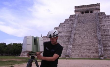
Researcher Cory Jaskolski scanning Kukulkán temple. (PHOTO: Karla Ortega, Proyecto Gran Acuífero Maya)
In 2015, a team led by René Chávez, researcher of the Geophysics Institute of the UNAM, revealed the existence of this sinkhole upon which one of their main temples had been
built. Now, the team of Guillermo de Anda seems to have found the entrance to the cenote in the ossuary room.
“Through the ossuary we can enter the cave beneath the structure and there we found a blocked passageway, probably closed off by the ancient Mayans themselves; we will
enter again and, this time, we will try to open it to see if the passageway leads us to the entrance of the cenote beneath the Castle,” said the archeologist during an interview.
De Anda points out one of the objectives of the exploration in Chichén Itzá is, precisely, to look for tunnels or passageways connecting the ossuary sinkhole to the castle.
“First we want to prove it exists because no one has seen it, we only have the images; then we’d have to explore it,” adds the researcher.
The Project also receives the collaboration of the National Geographic Society, the Mexican National Institute of Anthropology and History (INAH), and of James Brady,
researcher of the California State University and pioneer in Mayan cavern exploration.
Another of the objectives of the project is to develop a 3D map of the underground caves and labyrinths. For this task, the team is using cutting-edge tools developed by engineer Corey Jaskolski, explorer of the National Geographic Society; as well as a ground-penetrating radar and other devices such as drones with LIDAR technology.
Source: eluniversal.com.mx


