
With a hurricane watch in effect, Tropical Storm Nate poses the threat of torrential rains, flash floods and possible high winds as it strengthens and moves toward the Yucatan Peninsula on Friday Oct. 6
Nate drenched Central America with heavy rainfall producing deadly flash flooding on Thursday.
Civil Protection brigades were being mobilized late Thursday for parts of eastern Yucatan State and Quintana Roo, where a hurricane watch is in effect through Friday. The storm is expected to lash the Yucatan Peninsula Friday night and early Saturday.

The hurricane watch issued by the National Hurricane Center in Miami stretched along the Caribbean coast of Quintana Roo State, including Cancun and Playa del Carmen, to the fishing port of Rio Lagartos, located on the Gulf of Mexico in eastern Yucatan State.
“Nate is projected to move northward and become a hurricane despite brushing land in Nicaragua, Honduras and Mexico’s Yucatan Peninsula,” according to AccuWeather Meteorologist Brett Rossio.
Because of the proximity to land, people may have little time to react and prepare for a tropical storm or hurricane.
As of Thursday evening, at least 10 people were dead in Costa Rica and Nicaragua with more missing, according to Reuters.
Costa Rica President Luis Guillermo Solís declared a state of national emergency for the entire country Thursday morning.

“Since the system will be moving over very warm waters, we could quickly have a powerful hurricane on our hands,” according to AccuWeather Hurricane Expert Dan Kottlowski.
A storm that reaches Category 1 status has the potential to reach Category 2 or 3 (major hurricane) status in a matter of hours.
In the short term, the most likely area for rapid strengthening will be the stretch of water north of Honduras and east of Belize.
Even a weak tropical storm has the potential to bring flooding rainfall and dangerous surf and seas.
The intense rainfall is expected to lead to widespread flooding and mudslides across Central America, southeastern Mexico and western Cuba.
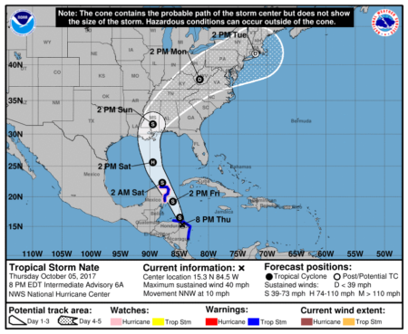
Map: U.S. National Hurricane Center
By Robert Adams for TYT with information from National Hurricane Center, accuweather.com, Diario de Yucatan, Excelsior, Reuters
