
Rain and high temperatures are forecast for Yucatan….
MERIDA — Although on Monday September 4 thermometers registered a high of 33.7 Celsius degrees (92.66, Fahrenheit degrees) at 3 p.m., Meridanos continued to suffer the effects of high temperatures, as the maximum heat index reached 46.7°C (116.06°F), at 5 p.m.
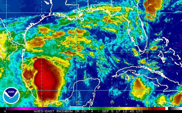
The forecast of rains continues for this zone in the next days, and with them the heat and the diverse precipitations, which are due to the effects of a low pressure area that is located to the south of the Gulf of Mexico that has a 40% chance of evolving and bringing winds of 25 kilometers per hour (km/h), (15.53 miles per hour).
For today Tuesday September 5, the effects of a trough that is located on the region are expected to cause the increase of clouds in the afternoons and rains in the northwest and southern portions of Yucatan; center and south of Quintana Roo, and center and south of Campeche.
(Image: SIPSE, Milenio Novedades)
For tomorrow Wednesday September 6, a low pressure area will favor strong storms in the east, center and south of Yucatán; north and center of Quintana Roo; and north and south of Campeche.
Meanwhile, for Thursday Sept. 7, the low-pressure area and tropical maritime air supply will generate showers to heavy storms in the northern, eastern and southern portions of the state; north and center of Quintana Roo, and, north and center of Campeche. The presence of electrical activity and strong wind gusts in storm areas is not ruled out, so precautions are recommended.
Regarding temperatures, for the next days are estimated maximum values of 33.0°C (91.4°F) to 37.0 °C (98.6°F) for Yucatan and Quintana Roo, while for Campeche are predicted values during the day that would oscillate between 32.0°C (89.6°F) and 36.0°C (96.8°F).
The winds would be from the east southeast at 15 to 25 km/h (9.32 to 15.53 M/H) with gusts of up to 45 km/h (27.9617 M/H) in the coastal zone of the three states of the Yucatan Peninsula.
The Navy reports that the ports are open to navigation, but recommend caution due to the waves that are now one or two feet high and expected to exceed three.
On Monday Sept. 4, according to the Conagua Observatory, Merida recorded a minimum temperature of 23.6°C (73.4°F) at 6 a.m., the thermometer rose to 33.7°C (92.66°F) in the afternoon; the highest humidity was 99% at 5 a.m. and the lowest at 70% at 2 pm; the most intense wind was 20.1 km/h (12.48 M/H) and was recorded from noon to 3 pm. Without rain, the UV index reached 12.4.
Source: sipse.com/milenio
