
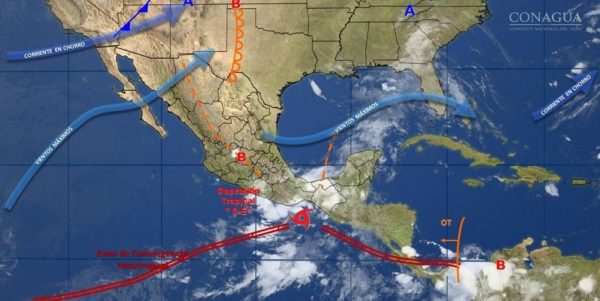
Strong winds with gusts above 60 kilometers per hour in the north and south of the national territory will prevail this week, due to the tropical depression 3-E, according to information from the National Meteorological Service (SMN).
MERIDA — The Yucatan Peninsula’s unsettled weather is expected to continue this week, and weather forecasters are keeping their eyes on systems forming over the Pacific and Atlantic Basin.
(Image: Noticieros Televisa)
While there is no tropical activity brewing right now in the Caribbean Sea or the Gulf of Mexico, “tropical development” is a possibility, according to NOAA.
Long-range guidance suggests possible hurricanes somewhere in the western Caribbean or near the Yucatan Peninsula between Saturday, June 17 and Friday, June 23.
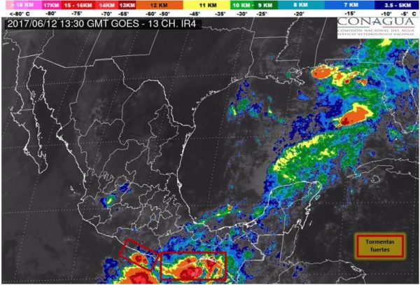
Although satellite data showed a flareup of thunderstorms, neither of the storm systems in the Atlantic or Pacific oceans is now expected to produce a hurricane.
The American GFS model and its European counterpart have been very consistent in showing some kind of a tropical low pressure system in this region during this time period, writes Jake Reed of Huntsville, Ala.,’s WHNT News 19.
“There is no reason to panic or cancel any plans right now, but be aware that this is something you will start to hear more about in coming days and weeks, especially if this trend continues,” writes Reed.
“Tropical development is not unheard of in the Gulf of Mexico during June, so we cannot totally take this possibility off the table right now.”
(Image: National Meteorological Service)
Also a report from the SMN of the National Water Commission (Conagua) indicated that conditions will also be maintained from very strong to intense storms in the south and southeast of the country.
Potential strong storms, showers, and hail could develop in addition to the presence of lightning and thunder, in southern, southeast, central and eastern Mexican states.
In the Yucatan Peninsula, cloudy skies are forecast with a 60% chance of strong storms in Campeche, rainfall intervals in Yucatan and scattered rains in Quintana Roo.
Also expected are warm temperatures and wind from the east and northeast of 15 to 30 kilometers per hour with gusts higher than 60 kilometers per hour to the passing of storm systems.
In addition to channels of low pressure over the interior of the territory and a cold front of short duration.
As well as potential for strong storms, squalls, fall of hail, as well as the presence of Thunder and lightning, about South, Southeast, Central and Eastern states.
In the Gulf of Mexico will dominate the cloudy skies with a 60 percent probability of intense isolated storms in Veracruz and Tabasco, and scattered rains in Tamaulipas.
As well as warm atmosphere and wind westerly 15 to 30 kilometers per hour, with gusts exceeding 40 km per hour during the passage of the storm systems, as well as superior to 60 kilometers per hour with storms and whirlpools in Tamaulipas.
Sources:
- yucatan.com.mx
- noticieros.televisa.com
- yucatanexpatlife.com
