
Forecasters are keeping a wary eye on a disturbance in the Caribbean Sea Monday Aug. 1 that may develop into a tropical storm later this week as it heads toward the Yucatan Peninsula and the Gulf of Mexico.
The storm is in the central Caribbean about 350 miles east-southeast of Kingston Jamaica, according to the National Hurricane Center. It is generating strong thunderstorms and packing winds up to 45 mph as it churns west at about 25 mph.
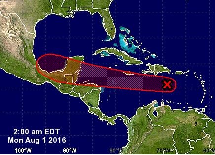
A satellite image from the U.S. National Weather Service shows the location of a tropical disturbance Monday, Aug. 1. The image indicates a high probability that a cyclone will form by Saturday, Aug. 6.
Forecasters said the depression is showing signs of development and it may become a tropical storm by Thursday and strengthen more by Friday as it enters the Bay of Campeche.
The system will likely head toward Mexico and have minimal impact on the U.S. other than increased rain showers and gusty winds in southeast Texas.
As of Monday morning the weather system designated 97L still lacked an obvious center of circulation. However, the hurricane center said that circulation was in the process of becoming better defined. If it continues to organize, forecasters said, a tropical storm is likely to form later Monday, and its name would be Earl.
Name or no name, the system is expected to bring heavy rain and gusty winds to parts of the Dominican Republic and Haiti today.
Those same conditions are expected to affect Jamaica this afternoon or tonight, and the Cayman Islands overnight, the hurricane center said.
The question is the potential Earl’s path.
The hurricane center’s five-day outlook takes the storm south of Hispaniola and Cuba and across Belize and Mexico’s Yucatan Peninsula. If that path were to hold it would then emerge into the southern Gulf of Mexico and could possibly take aim on Mexico’s Gulf Coast.
Once over the Yucatan Peninsula, the system will weaken, but locally torrential rainfall and gusty winds will continue in the region during Wednesday night and Thursday.
There is a chance the system will move back out over the waters of the southwestern Gulf of Mexico before the end of the week, where renewed strengthening could occur, stated AccuWeather Hurricane Expert Dan Kottlowski.
“A second landfall could occur in northeastern Mexico during Friday or this weekend, depending on the system’s track,” he said.
While dry air surrounds the system, disruptive winds in the path of the system are decreasing and water temperatures are in the middle 80s F (29-30 C).
The warm water, diminishing disruptive winds and a decrease in forward speed should cause the system to strengthen to a tropical storm and perhaps a hurricane, prior to reaching the Yucatan Peninsula and Central America.
