
Cutting-edge technology is enabling a team of experts to discover and map previously unknown cenotes, or sinkholes, on the Yucatán Peninsula and is also helping to confirm the existence of one previously detected beneath the main pyramid at the Chichen Itzá archaeological site.
A team made up of archaeologists, biologists, underwater photographers and cave divers has been working since the middle of last year to explore, document and map the extensive subterranean network of water deposits on the Yucatán Peninsula. It aims to eventually study at least 6,000 cenotes across the region.
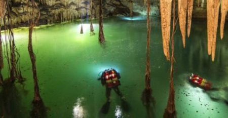
Photo: mexiconewsdaily.com
The existence of a cenote beneath the pyramid known as El Castillo (The Castle) or the Temple of Kukulkán was first detected by National Autonomous University (UNAM) researcher René Chavez in 2015 using a method called electrical resistance survey but now the GAM team hopes to physically confirm his finding.
“. . . We are now using ground-penetrating radars, a side-scan sonar . . . drones and a [3D] scanner,” said Guillermo de Anda, an underwater archaeologist and the project’s director.
De Anda explained that for Mayan people, cenotes were not just a water source. They had an important symbolic meaning and guided their design and construction decisions.
He added that the GAM project will lead not only to enhanced knowledge of the region’s geography but also a greater understanding of the Mayan people’s beliefs and way of life.
“Finding this cenote beneath the pyramid of Kukulkán of the ancient city of Chichen Itzá, Yucatán, would completely change the vision we have about the patterns of Mayan settlement . . . and would [allow us to] really perceive the Mayan and Mesoamerican worldview,” he said.
Apart from confirming the presence of the cenote, the GAM team also plans to complete a digital 3D map of the underground topography of the world heritage-listed site.
The National Geographic Society is providing funding as well as high-tech equipment to aid the team in its study of the underground characteristics of the site and an international team of experts is also contributing to the efforts.
Through the mapping process, researchers aim to gain a greater understanding of the connections between wet and dry caves, tunnels and the relationship between the locations of different pyramids in order to better appreciate the reasons behind the design of the site.
“. . . [Chichen Itzá] is one of the most explored sites but one of those that we know the least about,” de Anda said.
He explained that Mayan people considered the unique geography of the Yucatán Peninsula as a means to connect them to their religious beliefs.
“Unlike the European worldview where deities were in the sky, in the Mayan world the most sacred and living thing was the Earth. That’s why formations like caves and cenotes were so sacred; they were an entry point to the interior of the Earth, in other words, to the presence of the gods,” Brady said.
Source: mexiconewsdaily.com, Milenio (sp)
