

Experts predict waves from 3 to 5 meters high in Quintana Roo….
Tropical Storm Franklin could be near hurricane strength when it hits the Yucatan Peninsula Monday evening Aug. 7.
The National Hurricane Center in Miami reported at 5 a.m. Monday that Franklin’s top winds already strengthened to 45 mph (75 kph) in the northwestern Caribbean, where it’s moving west-northwest at 13 mph (21 kph) off the coast of Honduras.
It was expected to hold that course, making landfall at the Yucatan Monday evening, then crossing over the Gulf Tuesday on a path to central Mexico. A Hurricane Watch is in effect for the coast of Mexico from Chetumal to Punta Allen, and with tropical-storm-force winds extending up to 140 miles (220 kilometers) from the center, Belize could feel the effects by late afternoon.
Tropical storm Franklin gradually strengthened Monday morning August 7 in the Caribbean east of Honduras as it heads toward the Yucatan Peninsula, the US National Hurricane Center reported (NHC).
A bulletin indicated that at 08:00 am local time (12:00 GMT) Franklin had maximum winds of 75 kilometers per hour and its center was located 400 kilometers east of Chetumal, Mexico. The storm moves west-northwest at a speed of 20 kilometers per hour and his winds extend up to 220 km from the center to the periphery of the system.
In the predicted trajectory the Center projects that the storm will pass to the north of Honduras today and soon it approaches the east coast of the Yucatan Peninsula in the evening-night.
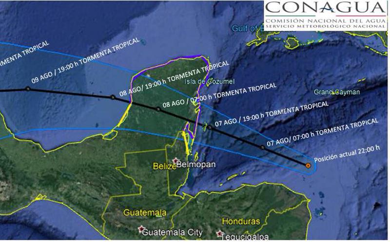
Storm’s predicted trajectory (Image: Sipse, Conagua)
A hurricane warning is in effect for the Mexican coast from Chetumal to Punta Allen, which means that these conditions are possible within the surveillance zone within the next 24 hours, according to the NHC. A tropical storm warning is in effect from Belize City north to the Mexican border, as well as along the Mexican coast from Chetumal to Campeche.
For Cancun cloudy skies are forecast, 80% of intense popup storms in the region. Hot and windy conditions of the east and northeast with gusts higher than 70 km / hr in Quintana Roo and 60 km / hr in Yucatan, as well as waves of 1 to 2 meters in Yucatan and 3 to 5 meters in Quintana Roo, reported the National Water Commission (Conagua)
Based on the assessment and analysis of the meteorological information in general and the forecasts of the National Meteorological Service, the following information is reported:
In Quintana Roo the yellow alert was activated, because the Tropical Storm Franklin in the Caribbean Sea was located today at 05:00, at the coordinates 17.1 degrees North latitude and 84.2 degrees longitude west, approximately 460 Km, east / southeast of Chetumal, Quintana Roo; And at 425 east of Cd., Belize, C.A., presents west / northwest movement (300 °) degrees at a rate of 20 kph; it had maximum winds near the center of 55 kph and gusts of 93 kilometers per hour.
For its current trajectory and gradual approach to the coasts of the State of Quintana Roo, it is advised that the storm represents a risk of impact. It is recommended that the population in general be aware of the notices and attend to the recommendations that are issued and disseminated through the official means of communication in the State on the monitoring of this tropical system.
Sources :
